We've compiled a list of 10 free and paid alternatives to RouteConverter. The primary competitors include GPSies, GPS Track Editor. In addition to these, users also draw comparisons between RouteConverter and GpsPrune, GPX Editor, Pytrainer. Also you can look at other similar options here: Travel and Location Software.
We've compiled a list of 10 free and paid alternatives to RouteConverter. The primary competitors include GPSies, GPS Track Editor. In addition to these, users also draw comparisons between RouteConverter and GpsPrune, GPX Editor, Pytrainer. Also you can look at other similar options here: Travel and Location Software.
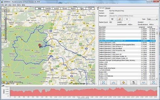
RouteConverter displays, modifies, enriches and converts GPS data between over 75 formats.
RouteConverter displays, modifies, enriches and converts GPS data between over 75 formats.
RouteConverter Platforms
Windows
Linux
Mac
RouteConverter Video and Screenshots
RouteConverter Overview
RouteConverter displays, modifies, enriches and converts GPS data between over 75 formats. It works without installation under Linux, Mac OS X and Windows, automatically detects the format of a file, supports drag and drop, undo and redo, offers a map view onto the positions of routes, tracks and waypoints, allows to modify positions in the map view, supports multiple routes within Google Earth, GPX and Garmin MapSource files, allows to select duplicate positions to remove them to abbreviate tracks, allows to move one or more positions of the route to the top, to the bottom, upwards and downwards, allows to complement elevation, place name, postal address, speed of positions from NASA SRTM3 and geonames.org, uses file and position names that suit to the display of the TomTom Rider, uses file, route and position names that suit to the display of the Map&Guide Motorrad Tourenplaner, remembers language, paths, window size and position